Tropical system likely to become Cat 3 storm before landfall
In an advisory issued late Monday by the National Hurricane Center, Potential Tropical Cyclone Nine’s projected cone has shifted to the east somewhat and the forecast path is narrowing.
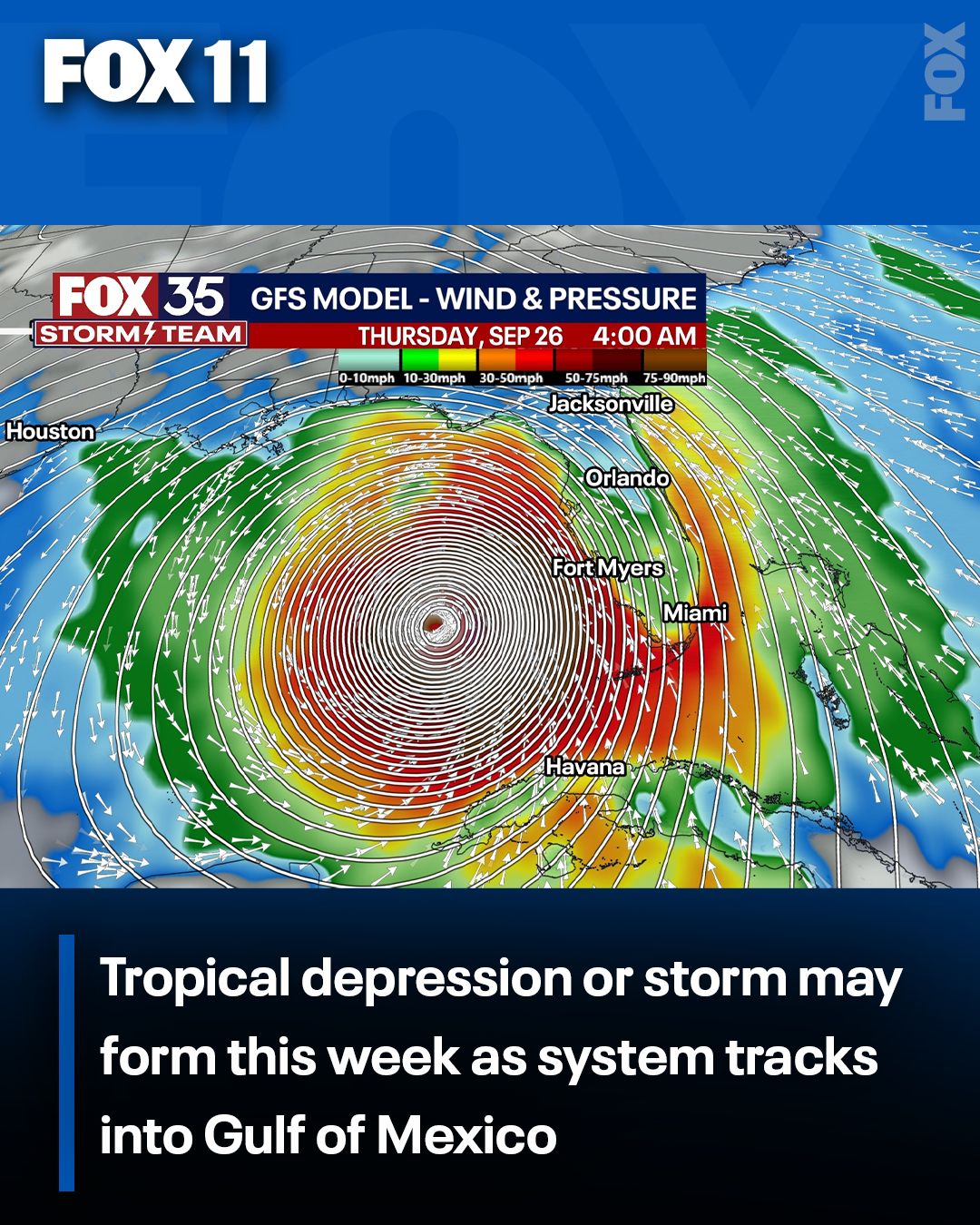
A tropical system is expected to rapidly intensify into a tropical storm and then a hurricane in the Gulf of Mexico before making landfall somewhere over Florida this week, according to the latest track and projections from the National Hurricane Center.
When it forms, it will be known as Helene, the eighth named storm of the 2024 Atlantic hurricane season. Regardless of where it makes landfall, Central Florida and Tampa will likely see impacts from the storm, including tropical storm-force winds, heavy rain, and perhaps a few tornadoes.
Ahead of the storm, Gov. Ron DeSantis has declared a state of emergency for 41 of the state’s 67 counties: Alachua, Bay, Bradford, Calhoun, Charlotte, Citrus, Collier, Columbia, Dixie, Escambia, Franklin, Gadsden, Gilchrist, Gulf, Hamilton, Hernando, Hillsborough, Holmes, Jackson, Jefferson, Lafayette, Lee, Leon, Levy, Liberty, Madison, Manatee, Marion, Monroe, Okaloosa, Pasco, Pinellas, Santa Rosa, Sarasota, Sumter, Suwannee, Taylor, Union, Wakulla, Walton, and Washington counties.
POTENTIAL TROPICAL CYCLONE UPDATE: LOCATION l TIMELINE l SPAGHETTI MODELS l FLORIDA IMPACTS | WATCHES & WARNINGS
Here’s the latest on Potential Tropical Cyclone Nine’s anticipated path, cone, timeline, and impact on Florida.
Where is Potential Tropical Cyclone 9 right now?
Potential Tropical Cyclone Nine is 100 miles southwest of the Grand Cayman Islands and 290 miles southeast of the western tip of Cuba.
It’s traveling NNW at 6 mph with sustained winds of 35 mph. A tropical storm has sustained winds of 38-73 mph, while a Category 1 hurricane has sustained winds of at least 74 mph. A northwestward motion is expected in the overnight hours.
“On the forecast track, the center of the system is forecast to move across the northwestern Caribbean Sea through Tuesday night, and then over the eastern Gulf of Mexico on Wednesday and Thursday.,” the NHC said.
Timeline: When it forms, when is Hurricane Helene expected to hit Florida?
The data is not concrete yet, but a hurricane is expected to be off the coast of Florida by Thursday morning.
Where it will make landfall, if it will make landfall over Florida, isn’t entirely certain. We’ll find out additional details in the hours and days ahead, as the system continues to develop.
According to the NHC, Potential Tropical Cyclone Nine is expected to become a hurricane on Wednesday and could become a major hurricane (Category 3, 4, or 5) before reaching Florida on Thursday.
Potential Tropical Cyclone Nine spaghetti models: Where is the tropical storm headed?
Potential Tropical Cyclone Nine is expected to develop into a tropical depression and “rapidly intensify” into Hurricane Helene. Some models suggest it could reach major hurricane status (Category 3 or higher).
How will the potential tropical storm impact Central Florida?
If the hurricane hits the western coast of Florida, Central Florida would be on the so-called “dirty” side – or western side – of the storm, which typically suggests more activity, in terms of thunderstorms and tornado potential.
Regardless of where it makes landfall, Central Florida will likely see strong winds, heavy rain, potential ponding or flooding in areas, and increased risk for severe thunderstorms and tornado warnings.
Potential Tropical Cyclone Nine Watches and Warnings
A Storm Surge Watch has been issued along the southwest coast of Florida from Bonita Beach to Flamingo. A Tropical Storm Watch has been issued along the southwest coast of Florida from Bonita Beach southward to Flamingo.
A Tropical Storm Watch has been issued for:
- Dry Tortugas
- Lower Keys south of the Seven Mile Bridge
- Bonita Beach southward to Flamingo

More radar maps from FOX 35 Storm Tracker Radar
- Brevard County
- Flagler County
- Lake County
- Marion County
- Osceola County
- Orange County
- Polk County
- Seminole County
- Sumter County
- Volusia County
- U.S./National Radar
Stay connected with FOX 35
- Download the FOX 35 News app for latest news, weather, and traffic alerts
- Download the FOX 35 Storm Team Weather app for live, interactive radar
- Visit FOX35Orlando.com/weather for interactive radar, plus updated weather graphics, maps, and images